
Several parts of Ireland are preparing for a sharp shift in weather conditions this weekend, as heavy rainfall and thunderstorms are forecast to move through numerous counties.
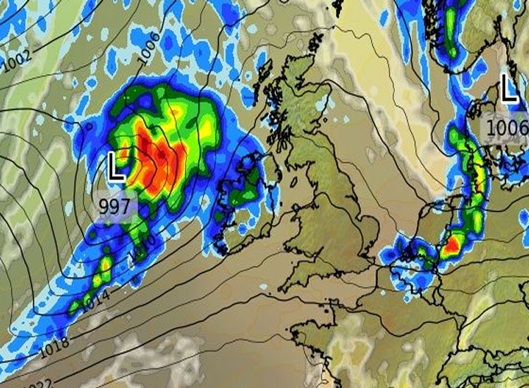
Met Éireann has released early warnings ahead of a significant low pressure system expected to arrive from the Atlantic on Saturday. The system is likely to bring intense rainfall and thunderous downpours, with coastal areas in the southwest predicted to experience the worst of the unsettled weather, reports The Mirror.
Although the exact strength of the weather front is still being monitored, the national meteorological service has issued alerts covering a 15-hour timeframe to ensure residents in at-risk areas can take necessary precautions.
The initial warning, a Status Yellow for Rain, will begin at 5pm on Saturday for Cork and Kerry and is set to remain active until 5am on Sunday, reports The Mirror.
A second Status Yellow warning applies to Waterford, starting at 8pm on Saturday and lasting until 8am on Sunday, reports The Mirror.
Met Eireann’s warnings state: “Spells of heavy rain with the possibility of a few thundery downpours. Potential impacts include localised flooding and difficult travelling conditions,” reports The Mirror.

The rest of the country won’t escape the brutal weather as the rain is set to sweep across Ireland on Saturday into Sunday. The full weekend forecast reads: “Saturday will be a dull and breezy day with scattered outbreaks of rain in the west and southwest at first, gradually spreading northeastwards across the country through the day. The rain will turn heavier in the south and southwest towards evening. Highest temperatures of 12C to 15C in fresh and gusty southeast winds, stronger near coasts. Wet and blustery Saturday night with heavy and persistent rain becoming widespread early in the night. Thundery bursts are possible with spot flooding likely. Rain will clear from the west and southwest by morning. Temperatures not falling below 10C to 13C in fresh to strong and gusty southeasterly winds, moderating and veering southwest in Munster and Connacht by morning,” reports The Mirror.
“Heavy and persistent rain at first on Sunday in the north and east, with further thundery falls and spot flooding possible. The rain will clear northeastwards through the morning with sunshine and showers following from the southwest, some of which will be heavy. Fresh to strong and gusty southeasterly winds at first but winds will ease moderate southwesterly behind the rain. Highest temperatures of 14C to 17C. Clear spells and showers for most Sunday night, though a longer spell of rain will move into the south and southwest, turning heavy at times. Lowest temperatures of 7C to 10C in light to moderate variable winds, with some mist and fog patches forming,” reports The Mirror.
Looking further ahead, the outlook for next week reads: “It looks set to turn somewhat more unsettled during the week as Low Pressure becomes more dominant than in preceding weeks. Mean air temperatures are forecast to be near or perhaps slightly above the climatological average. Rainfall amounts are forecast to be slightly below normal,” reports The Mirror.
Tell us your thoughts in the Facebook post and share this with your friends.

